
Citymapper- London,NYC,PAR,BER
FreeVersion 11.19
4.8(18)2024-07-18
Trusted App
Always get to your destination with Citymapper!
Previous Versions
Screenshots


Main features of Citymapper- London,NYC,PAR,BER
App description:
It provides comprehensive information with maps to get around the cities of London, New York, Paris, and Berlin.
Functions:
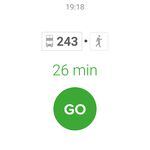
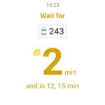
Has updated data so you can see the different public transport schedules in addition to receiving notifications that may affect your route.
Activities:
You can calculate distances to find the fastest route to your destination, whether on foot, by bus, subway, taxi, train or bicycle; you can mark the starting point and other places as your favorites.
Languages:
The interface is in English.
Recommendations:
Perfect for those who need to move fast and not get lost in the cities listed.
Platform:
Android phones and tablets.
Requirements:
Android 2.3 or higher.
Size:
39 MB
Operating System:
Android
Developer:
Price:
Free
Download options:
APK, Google Play
Developer´s description
App available in other languages
Tải Citymapper[VI]
Do you like Citymapper- London,NYC,PAR,BER?
3 Votes / 2 Likes
You might also be interested in:
Positive
A very handy app to travel without getting lost.
Attractive interface, and very easy to handle.
Available in English.
Constant updates.
Lots of information.
Very precise calculation of time and distance for the routes.
Latest Android NewsView more
Nominated apps & games for google play awards 2017
The Google Play Awards 2017 is coming up and the nominees for several categories have just been announced. The winner won't be
Best apps and gadgets for Android to rock your road trip
Nothing quite beats the feeling of exploring the world. Venturing from one city to the next, through different countries and


